8
Learning Objectives
- Identify the key geographic features of South Asia
- Explain the patterns of human settlement in South Asia
- Describe the cultural landscape of South Asia
- Analyze South Asia’s current population growth and future prospects
8.1 South Asia’s Physical Landscape
South Asia’s Himalaya Mountains are the highest in the world, soaring to over 8,800 meters (29,000 feet). Yet, these are also some of the world’s youngest mountains, reflecting a region that has experienced significant physical and cultural changes throughout its history. Here, we find one of the earliest and most widespread ancient civilizations, the hearth area for several of the world’s great religions, and a region whose population will soon be the largest on Earth.

South Asia is a well-defined region in terms of its physical landscape (see Figure 8.1). Formidable physical barriers separate the region from the rest of the Eurasian landmass. Much of the impressive physical geographic features of South Asia are the result of tectonic activity. Between 40 and 50 million years ago, the Indian Plate collided with the Eurasian plate (see Figure 8.2). Both the Indian Plate and the Eurasian plate were comprised of fairly low density material, and so when the collision occurred, the two landmasses folded like an accordion creating the mountain ranges we see today. The Indian Plate is still moving towards the Eurasian plate today and over the next 10 million years, will move an additional 1,500 km (932 mi) into Asia.
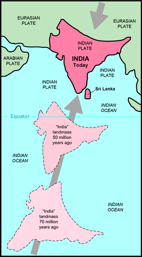
This massive tectonic collision resulted in perhaps the most well-known physical feature in South Asia: Mount Everest. Everest, located in the Himalaya Mountain range on the border of Nepal and China, is the highest mountain in the world. Because the India Plate continues to collide with the Eurasian Plate, this mountain range is still tectonically active and is rising at a rate of 5 mm each year. Thus, if you’re planning on scaling Mount Everest in ten years, be prepared to climb an extra two inches.
Although the Himalaya Mountains are well-known for having the highest peak, the Karakoram Mountain range, passing through Pakistan, India, China, and Afghanistan, has the highest concentration of peaks above 8,000 meters (26,000 feet). Its highest peak, K2, is the second-highest mountain in the world and far fewer people have successfully made it to the top compared to Everest. One in four people die while attempting to summit.
Another key physical feature of South Asia, the Deccan Plateau, was also formed from the region’s tectonic activity. Around 65 million years ago, there was an enormous fissure in Earth’s crust which led to a massive eruption of lava. The entire Indian peninsula was buried in several thousand feet of basalt, a type of dense, volcanic rock.
South Asia’s rivers, including the Indus, Ganges, and Brahmaputra form a lowland region that was home to several ancient civilizations. Today, these rivers provide for the water needs of many of this region’s people, irrigation for agricultural lands, and an abundance of fish. However, these rivers have had significant environmental concerns in recent years and have supported increasing numbers of people along their banks. Most of the area along the Ganges River, for example, has been converted into urban or agricultural land and the wild species like elephants and tigers that used to be present along the river are now gone. Pollution in the Ganges River has reached unprecedented levels as industrial waste and sewage is dumped untreated into the river despite the fact that people frequently use the water for bathing, washing, and cooking. It is estimated that around 80 percent of all illnesses in India result from water-borne diseases. The World Bank has loaned India over $1 billion to clean up the river, but experts believe that larger scale infrastructure improvements are needed to improve the region’s water quality.

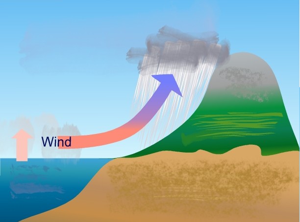
The most important climatic feature of South Asia is a dramatic weather cycle known as the monsoon (see Figure 8.3). The monsoon refers to seasonal shifts in wind that result in changes in precipitation. From October to April, winds typically come from the northeast in South Asia creating dry conditions. Beginning in April, however, winds shift to the southwest, picking up moisture over the Arabian Sea, Indian Ocean, and Bay of Bengal.
Most of the rain during the monsoon season results from orographic precipitation, caused when physical barriers form air masses to climb where they then cool, condense, and form precipitation (see Figure 8.4). India’s Western Ghats, a mountain range on its western coast, for example, causes orographic precipitation on its windward side. The Himalaya Mountains similarly result in orographic precipitation. However, these impressive highland areas are so formidable that they cause a dry area on their leeward side, known as a rain shadow. On one side of the Himalayas are some of the wettest places on Earth with over 30 feet of rain each year. On the other side, the rain shadow from the mountains forms the arid Gobi Desert and Tibetan Plateau.
The monsoon rains, though extreme, provide significant benefits for South Asia’s agriculture and economy. India gets more than 80 percent of its yearly rainfall from the monsoon and the rains are essential for both subsistence and commercial agriculture in the region. A good monsoon year will replenish the region’s water supplies and increase crop yields, driving down food prices. Ample rainfall also contributes to the region’s hydroelectricity potential. However, the torrential rains of the monsoon can also cause widespread flooding, destroying agricultural lands and transportation infrastructure, and can contribute to water-borne and insect-borne illnesses due to the significant amounts of standing water.
The monsoon is changing, though. Global changes in climate have made the monsoon harder to predict. In addition, rising numbers of automobiles across South Asia have increased air pollution, which can interfere with the mechanics of the monsoon. In the past, once the monsoon season starts, rains continue throughout the season. Recently, though, the monsoon rains have begun to stop and start throughout the rainy season. People in this region are generally unprepared for an unpredictable or variable monsoon season and rely heavily on the rains for agriculture. Local leaders are pushing for more research to better understand the shifting monsoon rains and for increased education on water conservation and sustainable agricultural management.
8.2 Patterns of Human Settlement in South Asia
South Asia’s rich cultural landscape is a product of its varied physical environment and long history of human settlement. Modern humans first settled in this area 75,000 years ago, and early human ancestors likely settled in the region hundreds of thousands of years before that. The first major civilization in South Asia was in the Indus River valley beginning around 3300 BCE. This civilization, located in present-day Pakistan, Afghanistan, and northwestern India, relied on the monsoon rains to provide water to the Indus River. Here, early settlers developed systems of urban planning, baked brick houses, and the civilization at its peak numbered over five million people.
By 1800 BCE, however, the Indus Valley civilization began to decline. Weakened monsoon rains likely led to drought conditions and even small changes in precipitation and climate can have a devastating effect on a population of five million. Although residents developed some systems of water supply, they largely depended on the monsoon rains for agriculture, and many began moving to other areas of the region as arid conditions increased.
Around 1500 BCE, the Aryans, an Indo-Iranian group from modern-day Iran, invaded northern India. The Aryans were speakers of Indo-Iranian languages and brought their language, known as Sanskrit, their culture, and their ideas of social order to the South Asian realm. Hinduism and the caste system would both emerge from the Aryan culture.
South Asia was conquered by a number of different empires, each leaving an impact on the cultural landscape. The Maurya Empire stretched across the Himalaya and Karakoram mountain ranges, extending into most of South Asia by 250 BCE followed by a number of different dynasties. In the middle ages, the Islamic Empire extended into Afghanistan and Pakistan.
In the 18th century, however, the ruling Islamic Mughal Empire was in decline, leaving a power vacuum that would be exploited by the British. As the Industrial Revolution swept through the United Kingdom, the British were interested in expanding their supply of natural resources. Throughout the mid-18th century and the early 19th century, the British Empire, which had established the British East India Company, took over large stretches of land in India. The British established tea and cotton plantations, and took control of South Asia’s resources. Although this region had previously established successful trading systems, the British saw local industries as competition and shifted their development to export raw materials. British rule also increased Westernization in South Asia and created an extensive rail transportation system.
As time went on, there were rising demands for independence. Mohandas K. Gandhi, known in India by the title “Mahatma,” was a London-educated lawyer and one of the leaders in India’s struggle for independence. He organized local communities to participate in nonviolent protests and his commitment to nonviolent resistance would inspire later civil rights leaders like Martin Luther King Jr.
Throughout this time, the isolated Himalayan countries of Nepal and Bhutan largely existed as buffer states, caught between the powerful British Empire and China. Their relative isolation allowed them to develop unique cultural features with little influence from outside groups, but as with most buffer states, left them with less economic and industrial development than their more powerful neighbors.
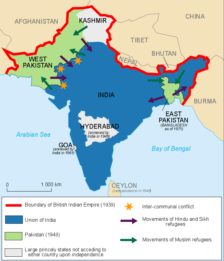
The British eventually agreed to withdraw from India but political and religious differences resulted in a partition of the former British territory in 1947 (see Figure 8.5). Areas that were majority Hindu would become the secular state of India. Areas that were majority Muslim would become the new Islamic state of Pakistan. Since Muslims were clustered both in modern-day Pakistan and along the mouth of the Ganges on the coastal Bay of Bengal, the Muslim state of Pakistan would be divided into a Western and an Eastern territory. This prompted large-scale migrations of Hindus and Muslims who were on the “wrong” side at the time of the partition.
Not everyone in South Asia supported the partition plan. Gandhi, who had long called for religious unity in the region, was opposed to the concept. Hundreds of thousands of people were killed in violent riots. In 1948, Gandhi was assassinated by a Hindu nationalist who opposed the partition plan and Gandhi’s commitment to nonviolence.
Furthermore, although there were areas that were clearly majority Hindu or majority Muslim, religious minorities existed throughout India and not all regions had an easy transition. At the time of the partition, states were free to decide whether they wanted to join Hindu India or Muslim Pakistan. In the territory of Jammu and Kashmir in Northern India (see Figure 8.6), Muslims comprised around 75 percent of the population but the maharaja, the Sanskrit term for “great ruler,” was Hindu. The maharaja struggled with the decision, and in the meantime, Muslim rebels, backed by Pakistan, invaded. He then gave the territory to India in exchange for military aid.

Today, Jammu and Kashmir still remains a contentious territory and there have been violent clashes in the past few decades over political control. In the 1950s, China, without the knowledge of India, built a road through the northern portion of the state and was given territory by Pakistan. Although India claims the entire state, it controls the southern half of the state and about four-fifths of its population. Pakistan controls the territory’s northern portion and moved its capital from Karachi to Islamabad to better control its frontiers. East Pakistan, long marginalized and culturally discriminated against by West Pakistan, gained independence as the state of Bangladesh in 1971.
As a region, South Asia is now the most populous area in the world and is home to over 1.8 billion people. Some of the world’s largest megacities are located here as well, including Delhi, India (population of 26 million in the entire metropolitan area), Karachi, Pakistan (population of 14 million, with some estimating that it is much higher) and Mumbai, India (population of over 21 million). Despite the sizeable population, however, the region remains largely rural. Only around 36 percent of people in Pakistan, 31 percent of people in India, and 28 percent of people in Bangladesh live in cities. These relatively low levels of urbanization indicate that most people in the region still practice agriculture.
Urbanization is increasing, however, as industrialization and development have brought new jobs to the cities. British colonization left the region with the English language which has proven an economic asset, though it has also led to the marginalization of indigenous languages. Foreign companies have increasingly outsourced to India, taking advantage of a large, low-wage and English-speaking labor pool. Outsourcing refers to contracting out a portion of a business to another party, which might be located in a different country. Business processing in particular, such as call centers and information technology, has been outsourced and employs significant numbers of people in India. India is also one of the global leaders in fiber production, and textile production remains an important part of Pakistan’s and Bangladesh’s economies as well.
Nepal and Bhutan remain isolated both in terms of physical geography and global economic integration. Political uncertainty has generally hampered economic growth in Nepal but the country has been able to reduce its poverty rate considerably in recent decades. Tourism to Nepal has also increased, though local leaders have expressed concern over mounting issues of trash and pollution as a result of climbers flocking to Mount Everest. In the early 21st century, Bhutan transitioned from an absolute monarchy to a constitutional monarchy and held its first general election. Its government has promoted the measure of gross national happiness (GNH), as opposed to relying strictly on measures of economic or industrial development and has sought sustainable ways to develop and urbanize.
8.3 Cultural Groups in South Asia
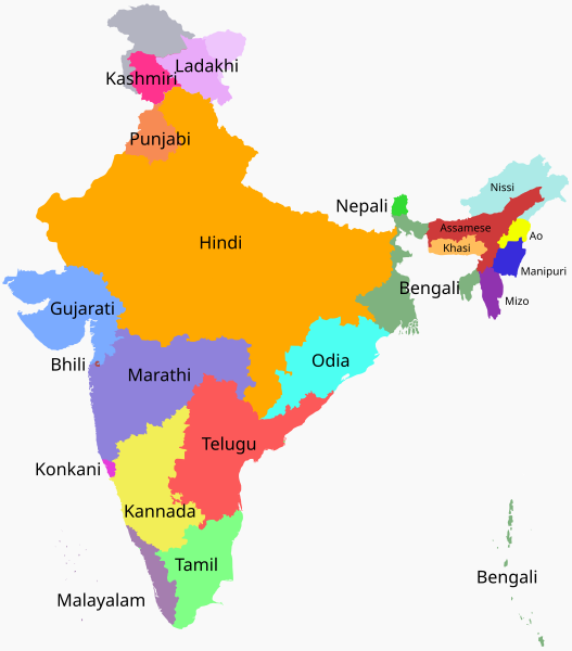
South Asia is a diverse region in terms of its ethnic landscape, culture, and religious beliefs. As shown in Figure 8.7, in the northern portion of the region, the Indo-European languages like Hindi dominate as a result of the Aryan invasion. Along the Himalayas, languages in the Sino-Tibetan family dominate. In southern India, however, most groups speak a language in the Dravidian family, comprised of the indigenous languages of South Asia that were present before the arrival of the Aryans. These language families reflect broader differences in culture and ethnicity, including particular religious practices and food customs. Thus the label “Indian cuisine” actually encompasses a diverse array of regional and traditional specialties.
South Asia is a hearth area for several of the world’s great religions. Out of the Aryan invasion of northern India came a religious belief system known as Vedism. The religious texts of Vedism, known as the Vedas, combined with local religious beliefs developed into the modern-day religion of Hinduism by around 500 BCE. Hinduism is a polytheistic religion with a wide variety of individual beliefs and practices. Hinduism is a highly regional and individual religion and its polytheistic nature reflects this open understanding of belief. Of Hinduism’s over 1 billion followers, 95 percent live in India.
At its heart, there are four key features of Hinduism: dharma, karma, reincarnation, and worship. Dharma refers to the laws and duties of being and is different for every person. You might be a student and an employee and a child and a sibling. All of those roles have prescribed responsibilities. To be a good student, for example, means to attend class, read the textbook, and study. In Hindu culture, there are also restraints and observances for how you interact with other people depending on their status.
Hindu views on the afterlife are quite different from the Judeo-Christian conception of heaven. Hindus believe in karma, which means that your deeds, good or bad, will return to you. They also believe in reincarnation, which is the idea that once you die, your spirit is reborn. Thus, you are the sum of numerous past existences. Karma, dharma, and reincarnation go hand in hand. If someone had done good deeds, had good intentions, and lived virtuously, when they die and are reincarnated, they might come back as something great – a prince, perhaps. Conversely, if someone was a terrible person, accumulating an excess of negative karma, when they are reincarnated, they might come back as someone of very low status – or maybe not even a person at all.
Hindu scripture discusses four distinct castes, or groups, of people in society, an example of social stratification. This social hierarchy is known as the caste system. The Brahmins, the highest caste, consist of priests and teachers and represent around 3 percent of India’s total population. There is a warrior caste, a merchant caste, and finally the lowest, the laborer caste of landless serfs. Excluded from this caste system, and viewed as so below it that they are not even a part of it, are the “untouchables,” also known as “Dalit” meaning “oppressed.” The untouchables are so-named because they perform work that makes them spiritually unclean, such as handling corpses, tanning hides, or cleaning bathrooms. Traditionally, higher castes would get ritually purified if they touch a Dalit. Many untouchables are indigenous, non-Aryan Indians.
So how might the belief in karma and reincarnation affect social justice in South Asia? Although the caste system was outlawed by the Indian constitution, widespread discrimination and persecution persists. Many Hindus believe that those in lower castes were reborn into that social status because they had committed misdeeds in their past life. However, other Hindus fought against the caste system and have worked to more fully integrate the Dalits into Indian society.
Buddhism emerged out of Hinduism in northern India following the life and teachings of Hindu prince Siddhartha Gautama. According to Buddhist belief, Siddhartha lived a life of luxury, but became disenchanted with his life of privilege when he was faced with society’s injustices, such as illness and extreme poverty. Since Hinduism offered no clear cessation of what Siddhartha viewed as an endless cycle of suffering through samsara, the soul’s continual death and rebirth, he sought out new ways of ending suffering. For a time, Siddhartha practiced meditation and extreme asceticism, eating only dirt and bits of rice. But neither the path of luxury nor the complete absence of worldly pleasures gave him the insight he sought. Eventually, Siddhartha, in meditation under a Bodhi tree in Bodh Gaya, India, discovered what Buddhists refer to as the Middle Way, a path of moderation. He is said to have achieved enlightenment and is known as the first Buddha, meaning “awakened one.”
Although Buddhism, like Hinduism, is a highly regional religion with many different forms of individual expression, Buddhists generally share a belief in the Four Noble Truths: 1) Suffering is universal and inevitable, 2) The immediate cause of suffering is desire and ignorance, 3) There is a way to dispel ignorance and relieve suffering, and 4) The eightfold path is the means to achieve liberation from suffering. Buddhists also share with Hindus a common belief in karma, dharma, and reincarnation.
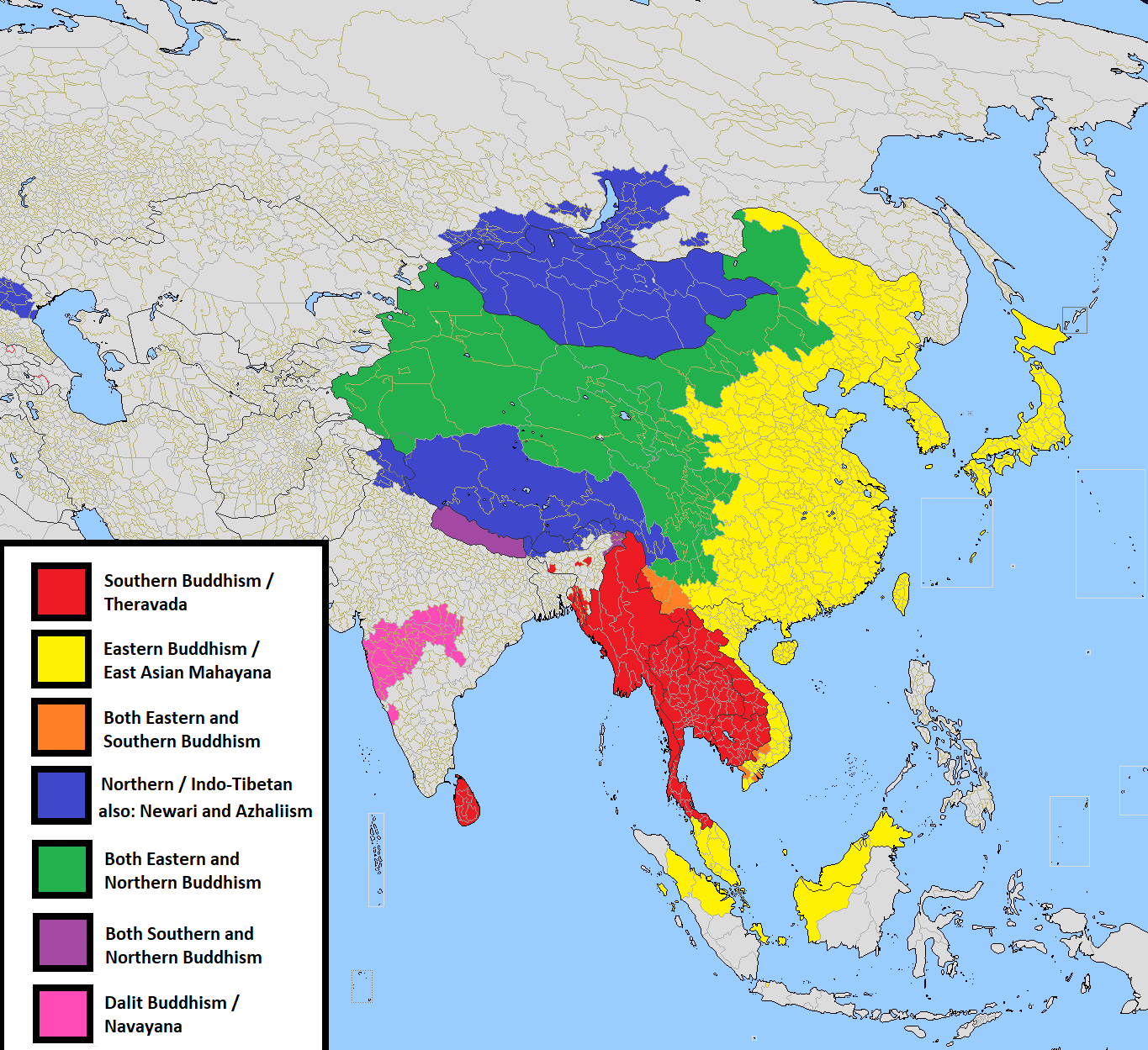
Buddhism diffused across Asia, though never taking a strong hold in India (see Figure 8.8). The Maurya Emperor Ashoka, in particular, was responsible for the widespread diffusion of Buddhism in the 3rd century BCE. The religion has three primary branches, each with a distinct regional concentration. The oldest branch, Theravada, is primarily practiced in Southeast Asia, in places like Cambodia, Laos, Myanmar, and Thailand and is also the majority religion on the South Asian island of Sri Lanka. Mahayana is practiced by most Buddhists worldwide, particularly in places like China and Japan. Vajrayana Buddhism, which is sometimes considered a subset of Mahayana Buddhism, is practiced in the Himalayas and Tibetan Buddhism is a notable example. Buddhism has around 500 million followers worldwide.
Although Buddhism and Hinduism are the most widely practiced, South Asia was also a hearth area for the Jain and Sikh religions. Jainism emerged in India in the first century BCE and emphasizes ahimsa, nonviolence toward all living beings. Even insects found in the home are gently ushered out rather than killed. Jains also seek to break free from attachments and inner passions, and aim to keep an open mind toward different perspectives. The teachings of Jainism were influential for Gandhi and his emphasis on nonviolent resistance.
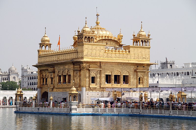
Sikhism emerged in the Punjab region of northwestern India and northern Pakistan in the 15th century. It is a monotheistic religion founded on the teachings of Guru Nanak that combines elements of both Hinduism and Islam. Like Hindus, Sikhs believe in reincarnation and karma. But unlike Hinduism, Sikhism prohibits the worship of idols, images, or icons. Sikhs believe God has 99 names, an adaptation of Hindu polytheistic belief. Sri Harmandir Sahib, commonly called the “Golden Temple,” in Amritsar, India is the holiest Sikh temple, which are called gurdwara (see Figure 8.9). However, the building is open to everyone and every visitor is offered a free meal. Over 100,000 people visit the site every day.
These religions, along with other minority religions like Christianity and indigenous belief systems, have not always coexisted peacefully in South Asia. Although India is officially secular, having no official religion, regional religious conflicts have often occurred throughout history. The difficulty is that in this region, very few people actually are secular, with no attachment to religion. Governments have thus struggled to find ways of accommodating minority religious groups while not offending the majority.
8.4 South Asia’s Population Dynamics
South Asia is the most populous region on Earth, but why is it the most populous, and how do geographers study population? The simplest way to measure population is to count the number of people in an area. India, for example, has a population of over 1.3 billion, making it the second-most populous country after China. But do raw numbers of people tell the whole story of the human population in an area? If two countries have the same population, but one is far smaller than the other, how could we examine population in a way that explores this difference?
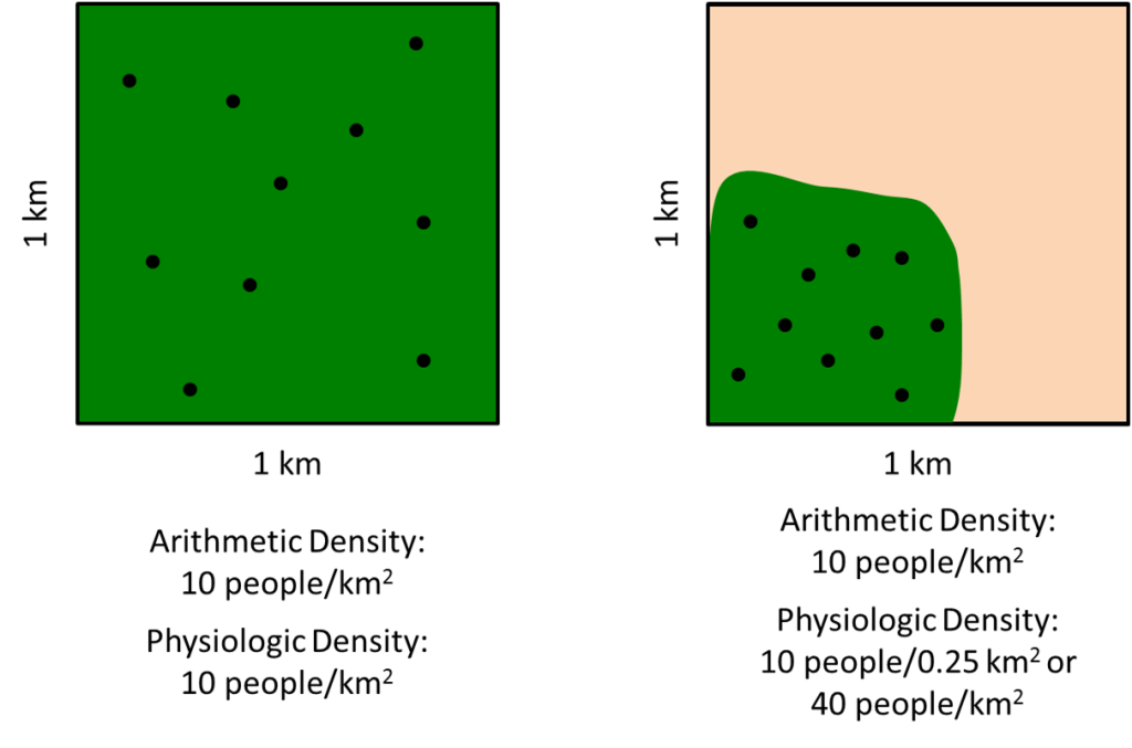
Geographers often use the concept of density to investigate population. Arithmetic density is fairly easy to calculate. It is determined by simply taking the number of people in an area divided by the size of the area. If a territory was one kilometer square, for example, and was home to 100 people, the arithmetic density would be 100 people per square kilometer. Although arithmetic density is easy to calculate, it gives us a fairly limited view of population density. What if there are two tracts of land that are the same size and have the same number of people, but one is lush and fertile and has people spread out evenly and the other has a tiny river that everyone lives near? If you were using arithmetic density, the measurements for these two areas would be the same even though the actual settlement patterns are quite different (see Figure 8.10). Physiologic density takes into account this difference by examining the number of people per unit of arable, or farmable, land.
Arithmetic and physiologic density can give us insight into the concentration of a country’s population and allows us to make comparisons between countries. The United States, a fairly large country, for example, has an arithmetic density of 32 people per square kilometer. However, a relatively small percentage of US land is arable, so the physiologic density is 179 people per square kilometer. Bhutan, by comparison, has a low population density of only 14 people per square kilometer. However, its rugged mountain environment means that only around 2 percent of the land is farmable, so its physiologic density is 606 people per square kilometer. By most measures, the most densely populated place in the world is Singapore with an arithmetic density of 6,483 people per square kilometer and a physiologic density of 441,000 people per square kilometer.
Another way to measure population is agricultural density which is the ratio of the number of farmers to the area of land. In developing countries where many people work as farmers, agricultural density is very high. South Asia has a high agricultural density. In developed countries, commercial agriculture and technological innovations have allowed relatively few people to be farmers and agricultural densities are generally low.
Geographers can also examine how a population is growing and changing over time. One way to explore this is with a population pyramid, a graphical representation of a population’s age groups and composition of males and females. Ages of people are grouped in cohorts with younger people on the bottom and older on the top. Thus, a population pyramid that is very triangular has a lot of young people and is growing rapidly.
Typically, the ratio of males to females, known as the sex ratio, is 1 to 1 and population pyramids will have even sides. However, in populations where males are favored, the ratio may be skewed. Similarly, in countries where men have died in war, such as in World War II Germany, there might be more females. When geographers and population demographers refer to sex, it means something different from gender; sex is a person’s biological identity as male or female while gender refers to a person’s role as a “man” or “woman” within society.
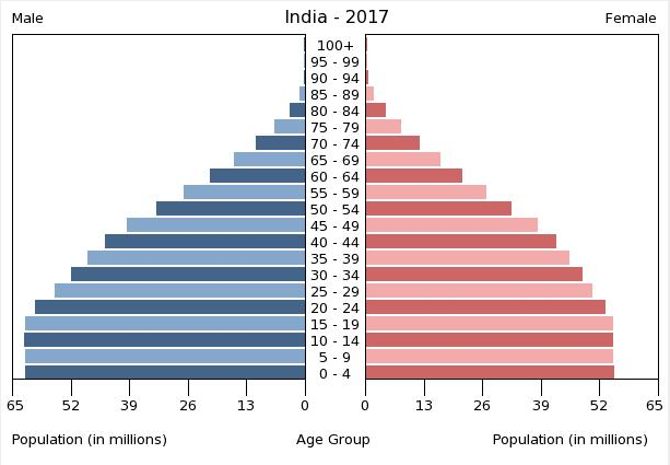
India’s 2017 population pyramid reveals rapid population growth over the past few decades (see Figure 8.11). However, the leveling off at the base of the pyramid indicates that population growth may be slowing. In addition, India’s cultural preference for male children is clearly apparent. Among children aged zero to four, India has 62 million males and only 55 million females. Nationwide, there are over 47 million more males in India than females. Both abortion and infanticide have contributed to this imbalance.
All of the population pyramids for the countries in this region reveal preferences for male children, though none are as severe an imbalance as India. Although Pakistan’s population growth has slowed in the past decades, its fertility rate remains the highest in the region at around 3.5, meaning a woman in Pakistan, on average, will have 3.5 children.
8.5 Future Challenges and Opportunities in South Asia
India’s male-skewed population pyramid is indicative of a larger issue of gender inequality in its society. Sexual violence in particular continues to be a significant issue. Although the percentage of women who have been raped in India is lower than in other countries, a majority of rape cases are never reported and even an incidence rate of 8 or 9 percent in a population of over 1 billion people means that tens of millions of women have been victimized. The government of India has taken steps to reform its criminal code so that more criminals are prosecuted but even after a 2013 reform, marital rape continues not to be a crime. In a country that has few female police officers, high rates of domestic violence, and a relatively low status of women, sexual violence will likely remain a problem until these broader, systemic issues are addressed.
Overall, South Asia’s growing population will have a significant impact on its geography. Much of the historic growth in this region was supported by the Green Revolution, which refers to changes in agricultural technology and productivity beginning in India in the 1960s. In 1961, India was at risk of widespread famine when a hybrid rice seed was developed that yielded ten times more rice than traditional seeds. It was called “Miracle Rice” and its use spread throughout Asia. Despite these agricultural advances, South Asia has the highest rates of child malnutrition of any world region. The low status of women in particular contributes to a lack of knowledge about the nutrients that are needed for children. Around one in three children in India are underweight.
Economically, South Asia has experienced rising prosperity yet systemic issues of governance and poverty remain. India in particular has one of the world’s largest economies and the fastest growing economy in the region. This economic growth has mainly been focused on urban centers, drawing large numbers of people from the rural countryside to the cities in hope of finding work. Many cities have been unable to accommodate the rapid migration, however, and the sprawling slums in India, Pakistan, and Bangladesh are indicative of inadequate infrastructure and economic inequality. Several factories in this region have collapsed in recent years, killing thousands of workers and highlighting the poor working condition of many South Asians.
What does the future hold for South Asia? Although economic growth has reduced poverty in India, down from 60 percent in 1981 to 25 percent in 2011, corruption has increased. Inequality between genders, religious groups, castes, and ethnic groups remains a problem in much of the region. In some cases, this has led to communal conflict, which refers to violence between members of different communities. In Sri Lanka, a majority Buddhist country, ethnicity and religion are closely linked. Buddhists here have shaken the traditional peaceful image of their religion and have engaged in violent conflict with the minority Tamils and Muslims.
Still, local government and community leaders have sought to escape the shadow of the 20th century’s turmoil by embracing new models of development and cooperation. In Bhutan, for example, the government initiative to measure gross national happiness resulted in shifting urban amenities, such as schools and healthcare clinics, to rural areas. This slowed the rural to urban migration that was rapidly occurring in other parts of the realm. Despite political and military turmoil, Pakistan has been able to substantially decrease its poverty rate. South Asia remains a complex realm at the crossroads of modernization and traditional cultural and religious values.
a seasonal shift in winds that results in changes in precipitation
rainfall that results from a physical barrier forcing air masses to climb where they then cool, condense, and form precipitation
a region with dry conditions on the leeward side of a highland area
a country situated between two more powerful states
the division of a territory into smaller units, as with the former British Empire in South Asia
contracting out a portion of a business to another party, which might be located in a different country
an ancient polytheistic religion that first developed in South Asia and is characterized by a belief in karma, dharma, and reincarnation
a system of social categorization where people in a society have differing levels of social status
a form of hereditary social hierarchy found in Hinduism
religion that emerged from Hinduism and is based on the teachings of Siddhartha Gautama
a religion emerged in India in the first century BCE and emphasizes ahimsa, nonviolence toward all living beings
a monotheistic religion founded on the teachings of Guru Nanak that combines elements of both Hinduism and Islam
the number of people in an area divided by the size of the area
the number of people per unit of arable land
the ratio of the number of farmers to the area of land
a graphical representation of a population’s age groups and composition of males and females
the ratio of males to females in a population
changes in agricultural technology and productivity beginning in India in the 1960s
violence between members of different communities
