7
Learning Objectives
- Identify the key geographic features of North Africa and Southwest Asia
- Describe the geography of the major religious groups found in North Africa and Southwest Asia
- Explain how the history of North Africa and Southwest Asia impacted its cultural landscape
- Describe the current areas of religious conflict within North Africa and Southwest Asia
North Africa and Southwest Asia’s Key Geographic Features
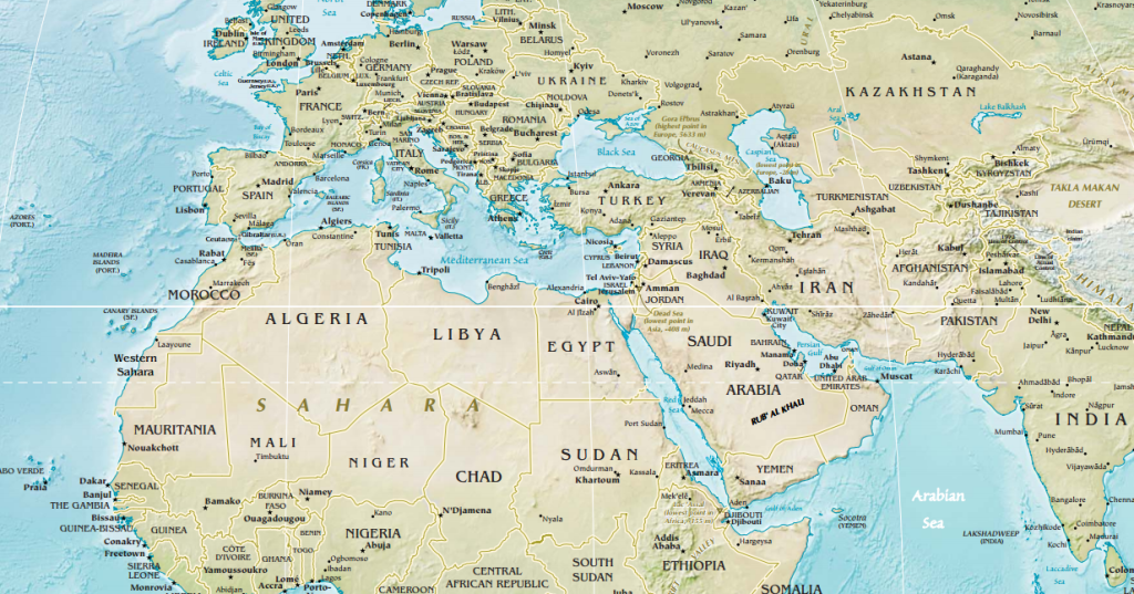
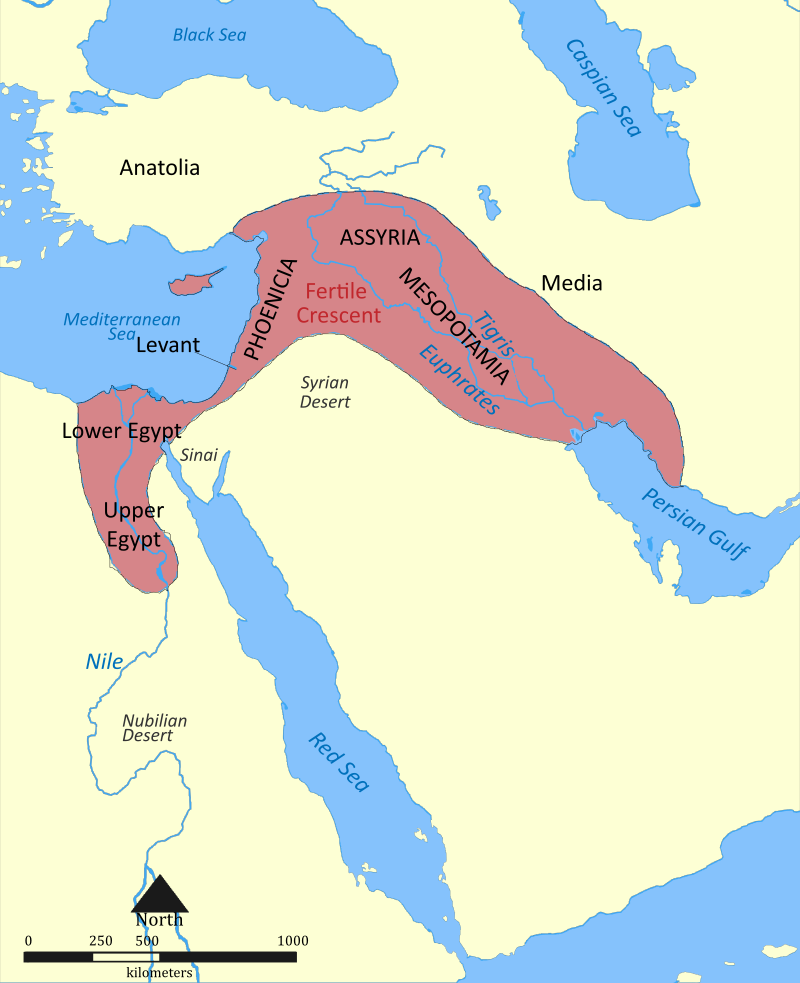
When geographers divide the world into regions, we often do so using landmasses. Have a big chunk of land might be mostly surrounded by water? Let’s make it a region! Sometimes, though, making these sorts of divisions is more difficult. Africa, for instance, is almost entirely surrounded by water except for a small land connection with Asia at Egypt’s Sinai Peninsula. But Sub-Saharan Africa is physiographically, culturally, and linguistically distinct from the African countries north of the Sahara. In fact, North Africa has much more in common in terms of its physical and religious landscape with the Arabian Peninsula and Southwest Asia than some of its continental neighbors to the south (see Figure 7.1).
Historically, this perhaps awkwardly named region of North Africa and Southwest Asia was commonly called the “Middle East.” This begs the question, though, what is it in the middle of? What is it east of? On a globe, east and west are relative terms. California is west of Europe but east of China. Indonesia is in Southeast Asia but is northwest of Australia. The equator might objectively be in the middle of the globe, but the “Middle East” is over 1,000 miles to its north. In truth, the term “Middle East” originated in Western Europe. Eastern Europe and Turkey were commonly referred to as the “Near East,” while China was called the “Far East.” The “Middle East” was thus in between these two regions.
Referring to the region as the “Middle East” seems to privilege the European perspective, so what alternatives exist? Perhaps you could call it the Islamic World? This would exclude places like Israel and secular governments like Turkey, as well as the numerous minority religious groups found in the region. You might have heard people refer to this area as the Arab World, but this would not apply to Iran, much of Israel, or Turkey. Thus we are left with simply the descriptive geographic name: North Africa and Southwest Asia, sometimes abbreviated as NASWA.
Whatever its name, this region is the hearth area for several of the world’s great ancient civilizations and modern religions. The landscape of North Africa and Southwest Asia, as its naming difficulties imply, is marked by regional differences: in culture, in language, in religion, in resources, and in precipitation. Even within countries, regional
imbalances exist both in terms of the physical landscape and the patterns of human activity.
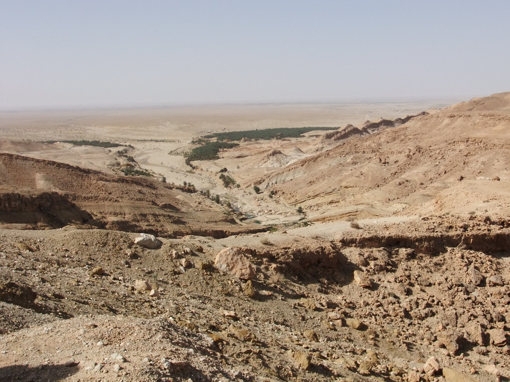
One of the most recognizable features of North Africa and Southwest Asia are its deserts. The Sahara, from the Arabic word ṣaḥrā‘ meaning “desert,” is the largest hot desert in the world, stretching across 9.4 million square kilometers (3.6 million square miles) of the North African landscape. Although the typical image of the Sahara is its impressive sand dunes, most of the desert is actually rocky (see Figure 7.2).
To the east, the Arabian Desert dominates the landscape of the Arabian Peninsula. In the southern portion of this desert is the Rub’al-Khali, the largest contiguous sand desert in the world. It is also one of the world’s most oil-rich landscapes. There are also a number of highland areas across the region including the Atlas Mountains of Morocco, Algeria, and Tunisia and the Zagros Mountains of Iran, Iraq, and Turkey.
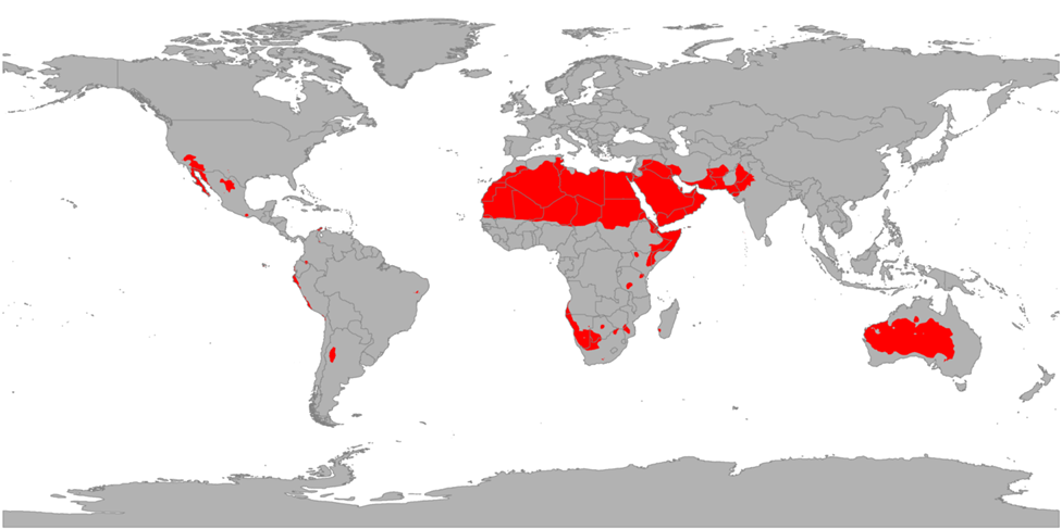
The prevailing climatic feature of North Africa and Southwest Asia is a lack of precipitation. From 10°to 30°north is a particular band of dry air that forms the region’s hot desert climate zone (BWh in the Köppen climate classification system) and is clearly apparent on a map of global climate regions (see Figure 7.3). Most of the region receives less than 30 cm (12 in) of rain each year. This hot desert environment means that much of the land in the region is unsuitable for cultivation.
There are exceptions to this arid environment, however. The region has a number of fertile river valleys and oases. The Nile River, for example, creates an arable floodplain in an otherwise extremely dry area (see Figure 7.4). While part of Iran is desert, northern Iran is actually home to dense rainforests and there are a number of scenic lakes. Coastal Turkey along the Mediterranean is often called the Turquoise Coast owing to its scenic blue waters. In general, however, those areas of North Africa and Southwest Asia where there is more abundant plant life are due to the presence of rivers, lakes, and seas rather than to the presence of ample rainfall.

In a realm largely defined by its arid and hot climate, global changes in climate could have profound effects. Climate and physical geography have already significantly constrained human settlement and development patterns in North Africa and Southwest Asia. Rising temperatures could exacerbate droughts, and heat waves and dust storms will likely become more frequent. In some areas, conflicts over limited water resources have already begun. The Nile River, for example, runs through ten different states and 40 percent of the entire population of Africa lives within its floodplain. Egypt consumes 99 percent of the Nile’s water supply, though, putting pressure on other countries, like Sudan, to keep water flowing downstream. Much of Egypt’s water demand is for the irrigation of cotton, but cotton actually requires a significant amount of water and is a nontraditional crop for such an arid environment.
7.2 Cultural Adaptations in North Africa and Southwest Asia
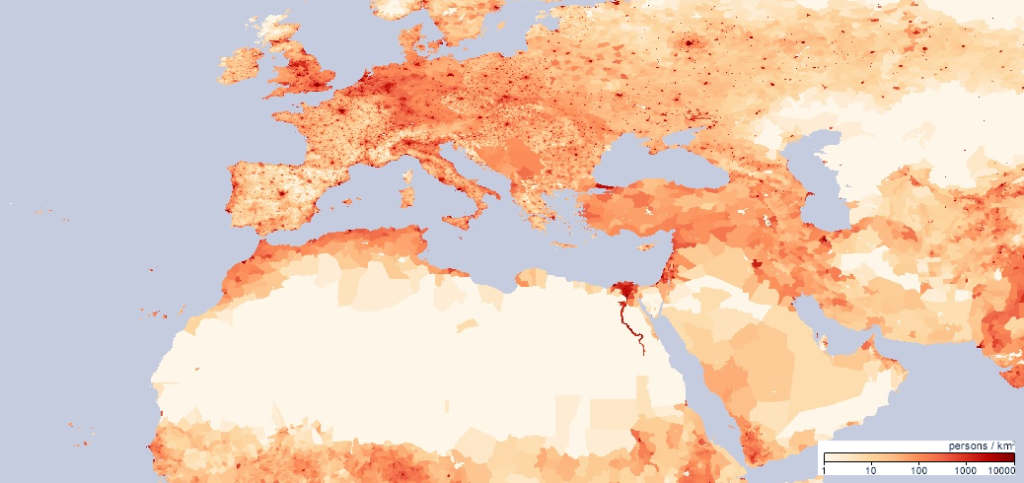
The climate and physical geography of North Africa and Southwest Asia have shaped population patterns and culture in the region. People in the region are generally clustered around the region’s sparse water resources reflecting ancient patterns of human settlement (see Figure 7.5). Four regions in particular stand out as having high population densities: the Nile River valley, the coastal Mediterranean Sea, the Euphrates and Tigris river basins, and valleys of northwestern Iran.
Over 10,000 years ago, the earliest humans in North Africa and Southwest Asia settled in the Fertile Crescent, the area surrounding the Tigris, Euphrates, and Nile rivers (see Figure 7.6). Here, humans first domesticated crops and animals and created the first farming settlements. In Mesopotamia, in particular, the river valley of the Tigris and Euphrates, innovations occurred that would change the trajectory of human existence. This was where the wheel was first invented, the first system of mathematics was created, and the first cereal crops, such as barley and wheat, were planted. Mesopotamia was also the site of the first urban civilization, called Sumer. Uruk, a city of Sumer, had a population of over 50,000 people by 2500 BCE making it the most populous city in the world at the time. The ancient city of Babylon, located between the Tigris and Euphrates, was inhabited for thousands of years and was likely the first city to reach a population of 200,000.
The people of this region have developed a number of adaptations to living in such a dry climate. Buildings are commonly designed with high roofs. Since hot air rises, having a higher ceiling allows the living area to remain relatively cool. Rooms are also often arranged around a common, shaded courtyard. This allows for maximum privacy, but also provides air flow throughout the living spaces. The traditional style of dress in parts of this region is also distinctive and reflects the physical landscape. Men might wear a cotton headdress to provide protection from the sand and sun as well as a long, flowing robe. Women’s traditional clothing in the region is more reflective of religious values than environmental factors.
For some cultural groups in the region, adapting to the physical environment means migrating to cooler areas during the hottest parts of the year. The Berbers, for example, an indigenous group in North Africa, traditionally herd livestock and migrate seasonally seeking water, grazing land, and shelter. However, the way of life for many pastoral nomads in this region, like some Berbers, has changed significantly in recent years. Many governments have encouraged these groups to practice settled agriculture rather than seasonal migration, and international boundaries have often cut off traditional migratory paths.
The Persians, from modern-day Iran, devised an innovative way to transport water known as a qanat. Qanats are underground tunnels used to extract groundwater from below mountains and transport it downhill, where it is used to irrigate cropland (see Figure 7.7). They were developed over 2,500 years ago and many old qanats are still in use today in Iran as well as Afghanistan.

In such a harsh, arid environment, agricultural potential is fairly limited. River valleys and coastal areas provided small stretches of fertile land, but in the absence of widespread agricultural development, what other resources could bring this region wealth? In the early 20th century, oil was discovered in Saudi Arabia and this natural resource would prove both a blessing and a curse to the region.
Today, Saudi Arabia remains the world’s leading oil exporter, shipping over 7.3 million barrels per day as of 2015. Kuwait, Iran, Iraq, and the United Arab Emirates are also among the top seven global oil exporters. Oil revenues have been able to increase development in these countries, financing industrialization, infrastructure, and providing high incomes. Qatar, for example, a small, former British protectorate on the coast of the Arabian Peninsula, has the highest GDP per capita in terms of purchasing power parity of any country in the world (as of 2018, according to the International Monetary Fund), at over $130,000 per person, largely due to its expansive oil and natural gas reserves. The tallest building in the world is now the Burj Khalifa, located in Dubai, United Arab Emirates. Although the United Arab Emirates, in building this 828 meter (2,717 feet) marvel, is seeking to diversify its economy and gain international recognition, its economy is still heavily dependent on oil.
Countries in the developing world with oil resources have often been prone to authoritarian rule, slow growth, corruption, and conflict. Oil wealth has been used to finance armies, and corrupt governments have pocketed oil revenue rather than reinvesting it in social programs or infrastructure. Furthermore, placing such a high emphasis on exporting one resource, like oil, has made this region vulnerable to changes in global energy demand. In 2015, countries in North Africa and Southwest Asia lost $390 billion in revenue due to low oil prices.
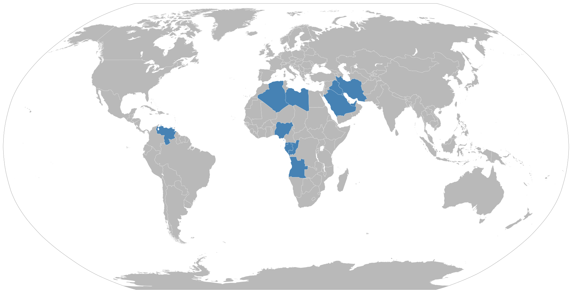
In an effort to coordinate oil production and prices, five countries including Venezuela, Iran, Iraq, Kuwait, and Saudi Arabia formed the Organization of the Petroleum Exporting Countries (OPEC) in 1960. Today, OPEC has 14 member states and covers over 40 percent of global oil exports (see Figure 7.8). OPEC cooperatively determines how much oil to produce and collectively bargains for the price of oil, rather than trying to compete to undercut one another. The United States and other countries have increased their own domestic oil production in recent years, causing OPEC’s global share of oil exports to decline.
The presence of oil has also left a colonial legacy across North Africa and Southwest Asia, and has made these countries vulnerable to foreign control and influence. In addition, the uneven distribution of oil resources and wealth has led to inequality both within and between countries. Ethnic inequalities have also emerged as groups have uneven access to oil reserves and income. Oil has also changed the pattern of human settlement in the region by bringing in migrants from outside the realm attracted by the prospect of economic opportunity.
7.3 The Religious Hearths of North Africa and Southwest Asia
North Africa and Southwest Asia is considered one of the great cradles of human civilization. It is also the hearth area for several of the world’s major religions. These religions have changed the global cultural landscape, but have also led to tension and conflict throughout the region. Three religions in particular, Judaism, Christianity, and Islam, trace their ancestry through the tribal patriarch Abraham, who may have lived sometime in the 2nd millennium BCE.
The oldest of these Abrahamic faiths is Judaism. Judaism is a monotheistic religion, meaning that it is defined by a belief in one god. Jews believe that Abraham established the first covenant with God and the central Jewish text, the Torah, includes a discussion of the creation of the world as well as the establishment of this covenant. The first Jewish temple, built by Solomon, was constructed in modern-day Israel around 832 BCE. The Babylonians destroyed both the city of Jerusalem and Solomon’s Temple in 587 BCE, and many scholars note that this event led to the creation of the written Hebrew Bible, what Christians term the Old Testament. The temple was reconstructed by Herod beginning in the 1st century BCE. However, this region has long been subject to invasion and conquest and in 70 CE, the Second Temple was destroyed by the Romans. This event prompted large-scale Jewish emigration from the region.
Both temples in Jerusalem were largely places of sacrifice and God was believed to literally dwell within the space. Thus, early Judaism was a temple-centered religion. The destruction of the Second Temple marked a distinct turning point in Jewish history between the historical Temple Judaism and modern Rabbinic Judaism. If a Jewish person is no longer defined by the sacrifices they make at the Temple, then what is it that makes someone Jewish? Rabbis and the interpretation of Jewish religious texts
became centrally important to creating new ideas of Jewish identity.
Today, there are around 14 million Jews worldwide; around 42 percent live in Israel, another 42 percent live in North America, and the rest live mostly in Europe. In addition, Judaism developed a number of different branches including Orthodox, which is more traditional, Reform, which is also known as Progressive Judaism, and Conservative, which is somewhere in the middle. Conservative is the largest branch of Judaism worldwide. However, millions of Jews around the world consider themselves to be unaffiliated or secular, emphasizing the ethnic and cultural values of the Jewish faith rather than the religious theology.
Christianity is another Abrahamic, monotheistic religion. It developed from the life and teachings of Jesus, a Jewish preacher who was born in 4 BCE in Judea, located in modern-day Israel. Jesus believed that the end times were near and emphasized love as the central religious doctrine. He was crucified by the Romans around 30 CE, a method of execution typically reserved for those who challenged the established social order.
Originally, Christianity was a sect of Judaism, but it eventually developed into its own, distinct religious tradition. A number of councils were held during the early years of
Christianity to create an agreed upon doctrine, though some of these decisions were disputed. Over the years, Christianity developed distinct branches and denominations. The first of these divisions, known as the Great Schism, came in 1054 CE and was as much a product of geography as theology. This split divided the Eastern Orthodox from the Roman Catholic churches. In 1517 CE, the German monk Martin Luther penned The Ninety-Five Theses, which criticized Roman Catholic doctrine and began the Protestant Reformation.
Christianity is the largest religion in the world today with over 2.2 billion adherents. Although there are a wide variety of individual Christian beliefs, Christians generally view Jesus as a divine figure and believe he was resurrected following his death. Roman Catholicism remains the largest single denomination of Christianity with 1.2 billion members particularly in Brazil, North America, Western Europe, and parts of Africa and South America.
The religion that is most characteristic of North Africa and Southwest Asia today is Islam. Islam teaches in the existence of one God and emphasizes the belief in Muhammad as the last prophet. Followers of Islam are known as Muslims. Islam builds upon much of Jewish and Christian theology. Like Judaism, Islam views Abraham, Noah, Moses, and others as prophets of God. Also like Judaism, Islam has a monotheistic understanding of God; God is simply known in Islam as Allah, from the Arabic al-ilāh, meaning “the God.” Islam teaches that Jesus was a prophet, and much of the story of his death and life in the Qur’an is similar to the story in the New Testament.
Muhammad was born in Mecca, in present-day Saudi Arabia, in 570 CE. Beginning when he was 40, Muslims believe that Muhammad began receiving revelations from God and later began preaching in his community. Muslims believe that the words of the Qur’an, the holiest book in Islam, contain the words of God as revealed to the Muhammad. Qur’an literally means “the recitation” in Arabic. In 622 CE, after widespread persecution, Muhammad was forced to emigrate to Yathrib, what is now the city of Medina, Saudi Arabia. This year marks the beginning of the Muslim calendar. In Yathrib, Muhammad gained converts and political authority and eventually the Muslim forces from Yathrib conquered Mecca, where Muhammad later died in 632 CE.
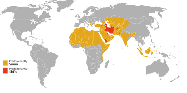
Immediately after Muhammad’s death, disagreements arose over who should succeed Muhammad as the leader of the Muslim faith. Most Muslims believed that the leader
of Islam should be the person who is most qualified. Today, this group represents the Sunni branch of Islam. Others, however, believed that the only rightful leader must be a blood relative of Muhammad. This group is known as Shia, which derives from the Arabic phrase shi’atu Ali meaning “followers of Ali,” who was Muhammad’s cousin and son-in-law. Sunni is still the largest branch of Islam today, representing around 90 percent of adherents while Shia constitute around 10 percent of all Muslims (see
Figure 7.9).
The Five Pillars of Islam form the foundation for Muslim life and practice. First, the pillar of Shahada refers to a declaration of faith. It is generally recited in Arabic but translates as ”There is no god but God (and) Muhammad is the messenger of God.” Stating this phrase with conviction is all that is required to convert to Islam. The pillar of Salat refers to prayer five times per day. When Muslims pray, they face the Kaaba in Mecca, a cubed structure that is considered to be the most sacred Muslim site in the world (see Figure 7.10). The third pillar of Islam, Zakat, refers to the giving of alms, or charity. Muslims are required to donate 2.5 percent of all assets each year.

The fourth pillar, Sawm, requires Muslims to fast during the month of Ramadan. During this month, adult Muslims abstain from food, drink, and sex during daylight hours. Those who are ill, pregnant, elderly, or are otherwise unable to fast are exempt from the requirement. The month-long fast is designed to bring Muslims closer to God, but also to remind them of the feeling of hunger in the hopes that they will be mindful of those who are less fortunate throughout the rest of the year.
Finally, the fifth pillar of Islam is hajj, a pilgrimage to Mecca that is expected for all physically and financially able Muslims to complete at least once in their lifetime. During the hajj, which lasts several days, Muslims complete a series of rituals, some dating back to the time of Abraham. In 2012, a record 3.16 million pilgrims completed the hajj and crowd control has been a significant concern as the numbers of pilgrims have swelled. Since 1990, several stampedes have occurred; the deadliest was in 2015 and killed over 2,000 people.
Islam is the majority religion in every state in this realm except for Israel. Globally, Islam has around 1.8 billion followers and is the fastest-growing of the world’s religions. Although this region is largely united by a belief in Islam, the divisions within the faith as well as the presence of numerous minority religious groups has often led to conflict.
7.4 Conquest in North Africa and Southwest Asia
After Muhammad’s death, Arab military forces carried Islam across the region. At its greatest extent, the Islamic Empire under the Umayyad Caliphate of the 7th and 8th centuries stretched across 15 million square kilometers (5.79 million square miles), from the Iberian Peninsula, the southwest corner of Europe containing Spain and Portugal, all the way across North Africa and the Arabian Peninsula and into Pakistan (see Figure 7.11). No empire would be larger until the Mongols in the 13th century.
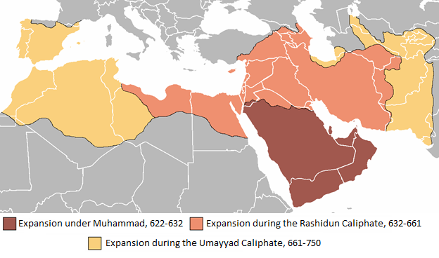
750 CE (Derivative work from original by Brian Szymanski, Wikimedia Commons, Public Domain)
The Islamic Empire continued for hundreds of years. Its capital moved from Medina to Damascus, the capital of modern-day Syria, and then to Baghdad, the capital of modern-day Iraq. By 1259 CE, however, much of this region, including Baghdad, was conquered by the Mongols, beginning a pattern of occupation and conquest that would
continue until modern times.
The Ottoman Empire, based in modern-day Turkey, followed, taking control of much of North Africa and coastal Southwest Asia by the 15th and 16th centuries. Though it declined over time, the Ottomans maintained control of much of the region until it, along with the Central Powers of Germany, Austria-Hungary, and Bulgaria, lost World
War I. Following World War I, the allied powers of Europe divided the former territory of the Ottoman Empire and carved out colonies.
The League of Nations, an intergovernmental organization which lasted from the end of World War I until the beginning of World War II, portioned the former Ottoman Empire and granted mandates for European powers to control parts of its territory. France, for example, was given a mandate for Syria. Britain was given a mandate to control Iraq as well as Palestine. The Italians, too, were able to take a piece of the Ottoman Empire, gaining control of Libya in the early 20th century.
As with many other parts of the world, the colonies of North Africa and Southwest Asia were formed with little attention to underlying ethnic tensions or resource issues. Some ethnic groups found themselves split amongst several different European colonies, while others were forced to share newly created territories with hostile groups. Even once colonies were able to get independence, these colonial-era issues would remain. Unevenly distributed oil wealth, which was not discovered in large quantities until after the withdraw of European powers, would further complicate political and economic stability in the region.
7.5 The Modern Political Landscape of North Africa and Southwest Asia
Today’s political map of North Africa and Southwest Asia reflects superimposed boundaries and a legacy of colonialization. The countries of this region have often been prone to political instability and conflict, and religious tension both between Muslims in this region as well as with the region’s many religious minorities has often led to violence.
One key issue is that the geography of this region has often restricted development and transit to fairly narrow channels. Conflict can often occur over the control of these choke points. A choke point is a narrow passage to another region, such as a canal, valley, or bridge. North Africa and the Middle East has several, strategically important choke points including the Hormuz Strait, which provides the only sea passage into the Persian Gulf, and the Suez Canal, which was built to connect the Mediterranean Sea to the Red Sea. Who controls these choke points, and who they allow through, has often been a point of contention.
European colonizers were generally slow to relinquish control in the region. Local groups often reacted violently in trying to secure independence. As a result, many newly created governments in the region consisted of military groups. In other cases, monarchs found either military support or joined with local religious leaders. For many areas in this region, the discovery of oil brought about significant wealth, but also reignited Western interest and involvement. During the Cold War, for example, the United States sought to limit Soviet influence in the region and maintain its supply of oil.
Conservative religious ideology has sometimes provided a reaction against Westernization and foreign influence. In Iran, for example, the 1979 Islamic Revolution was largely a reaction against Westernization under a US-backed leader. The revolution established a theocracy in Iran, meaning a rule by religious authority, with the Grand Ayatollah, a Shia religious cleric, as the supreme leader.
After the dissolution of the Ottoman Empire, the Saud dynasty partnered with the leader of the Wahhabi religious movement, creating the foundation of modern Saudi Arabia. Wahhabism is a strict form of Sunni Islam that promotes ultraconservative Muslim values. Women have a strict dress code emphasizing modesty and have guardians, usually a father, brother, uncle, or husband, and need their guardian’s consent to make major decisions or travel. Until 2018, women were forbidden from driving. A number of other practices are forbidden by Wahhabism, including watching nonreligious television programs, playing chess, and dancing. The penalties for breaking these prohibitions are often severe.
In Afghanistan, a group of militant Sunnis, known as al-Qaeda, fought against the Soviet Union’s invasion of Afghanistan. The organization was founded by Osama bin Laden and formed an alliance with the Taliban, an Islamic fundamentalist political movement also based in Afghanistan. With al-Qaeda’s military support, the Taliban were able to take control of Afghanistan from 1996 until 2001. They are known for their brutal oppression against women and acts of terrorism against civilian targets. As countries have modernized, Westernization and conservative religious values have continued to clash.
The landscape of North Africa and the Middle East remains in flux. The most widespread political change in recent years was a wave of protests and revolutions known as the Arab Spring. The Arab Spring began in Tunisia in 2010 when a fruit vendor set himself on fire after being harassed continually by police. Widespread protests in Tunisia followed his death, calling for changes to the country’s issues with corruption, high unemployment, lack of political and personal freedom, and high food prices. After just ten days of demonstrations, Tunisia’s president, Ben Ali, who had been in power for 23 years, fled in exile. From Tunisia, protests spread across the region, at times toppling governments that had been in power for decades (see Figure 7.12).

At the heart of the causes behind the Arab Spring is inequality. In much of this region of the world, wealth and power is concentrated in the hands of a select few. Young people in the region in particular had high levels of education but also high unemployment and played a central role in bringing about change. Social media was also used to organize and rally support, and diffused the revolution rapidly. Several of the countries that experienced an initial change in regime have seen several later waves of political change, as interim governments sometimes proved to be as ineffective as previous leadership.
In Syria, however, despite widespread initial protests and calls for a change in leadership, president Bashar al-Assad not only refused to step down, but violently opposed protestors. Syria has been ruled by the Ba’ath political party, a socialist and nationalist group seeking Arab unity, since the 1960s. Bashar al-Assad was elected president under a 2000 referendum and ran unopposed, giving some indicator of the lack of political freedom in the country. Soldiers were ordered to open fire on civilian protestors and many were killed or tortured. Eventually, the country declined into civil war, with the government fighting rebel groups who sought to overthrow it and civilians caught
in the crossfire.
The civil war in Syria also offered an opportunity for another group in the region to gain control of territory. ISIS, the Islamic State in Iraq and Syria, also known as the Islamic State in Iraq and the Levant (ISIL) or just the Islamic State (IS), emerged in 2014 as a Sunni extremist group opposing the United States’ invasion of Iraq. Iraq had been ruled by the minority Sunni population for centuries, but with the overthrow of then-president Saddam Hussein, also a member of the Ba’ath party, the majority Shia population took control. Efforts to create a coalition government and include Sunnis as well as the other minority groups in the country broke down. Some of the Sunnis who had been political leaders or military personnel under Saddam Hussein formed ISIS and were eventually able to drive out Iraqi government forces in several key cities.
From there, the group gained control of parts of Syria. For some time, much of Iraq and Syria existed as an insurgent state, a territory beyond the control of government forces. ISIS is widely known for its brutal tactics, including beheadings, sexual violence, and fundamentalist interpretation of Islam. The group sought to create a worldwide Islamic State with every Muslim country under its control. The United States declared ISIS defeated in 2019, though researchers note that while the US indeed took control of the last pieces of territories held by ISIS, thousands of ISIS fighters remain dispersed across Iraq and Syria and the group has the support of other affiliate groups and fighters across the world.
Since 2011, the people of Syria have endured government assaults, violence from rebel groups, and attacks from ISIS. Over 400,000 Syrians have been killed, many of them civilians, and over 13 million have become refugees. Some refugees have remained in Syria, cut off from aid by government and insurgent groups. Around 4.8 million people have left Syria. Some have fled to Turkey and Greece by boat; many have died on the perilous journey. Europe and North America have debated whether to accept these migrants, with some countries arguing that Syrian migrants might actually be terrorists, and others acknowledging that the global community has a responsibility to help those in need.
7.6 Religious Conflict in North Africa and Southwest Asia
The rise of ISIS is representative of many key issues of geography in this region: the intersection of religious values, political instability, and control of territory and resources. ISIS represents a fundamentalist view of Islam, known as Islamism. Islamism is characterized by a strict, literal interpretation of the Qur’an, conservative moral values, and the desire to establish Islamic values across the entire world. Militant Islamist movements have inspired the violent ideology of jihadism, which seeks to combat threats to the Muslim community.
Islamism and jihadism represent a small portion of global Muslim beliefs, however. A Pew Research Center survey found that in most countries, over three-quarters of the population of Muslims reject Islamic extremism and a majority expressed concern over religious extremism. Furthermore, even in North Africa and Southwest Asia, only one-quarter of Muslims believed that tensions within the community between more religious and less religious Muslims represented a major problem. In every religious community, there are fundamental interpretations of scripture and both conservative and liberal understandings of theology.
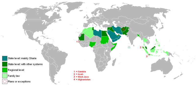
For traditional Muslims, religious life and personal life are intertwined, and thus political structures in this region have often reflected religious values. Several states in North Africa and Southwest Asia have declared sharia law, meaning that Islamic religious law applies in the court system (see Figure 7.13). Islamist groups in particular have often utilized a strict and harsh interpretation of sharia. In many countries, most Muslims believe that sharia should be the state law, but many believe it should only apply to the country’s Muslim population. In addition, Muslims differ in their interpretation of sharia, with some only supporting sharia for personal disputes but not accepting sharia’s harsh punishments for various offenses.
In a region where political boundaries were often contrived by outside forces, governments have struggled with their relationship to minority religious and ethnic groups. The modern state of Israel, for example, was created following World War II by a United Nations plan to partition the British-controlled Palestine into Arab and Jewish areas. A series of wars between Israel and the surrounding Arab states left Israel as an independent state in control of the territories of the West Bank and the Gaza Strip, which were originally intended to be Palestine. Jerusalem, which under the UN plan would be a neutral, international city because of its significance to several of the world’s religions, was proclaimed the capital of Israel.
Conflict continues between Palestinians living in territory controlled by Israel and Israelis who maintain sovereignty over the entire area (see Figure 7.14). Israel has built a series of walls dividing the West Bank and Gaza from the areas of Israeli control, maintaining that they are to protect Israelis from Palestinian terrorists. For Palestinians, however, these walls limit their freedom of movement and have often separated them from their livelihoods. The Gaza strip remains completely isolated, surrounded by walls on three sides and a sea controlled by Israeli ships on the other. Some have suggested a two-state solution and the creation of an independent, Palestinian state, but Israeli construction of homes in the West Bank has limited that option.

North Africa and Southwest Asia is a region of the world that is the cradle of ancient civilizations and modern religions, but where resources are limited and unevenly distributed. Religious tension and political conflict have persisted. Some groups like ISIS have taken advantage of instability and valuable resources like oil to carve out control of territory and finance armed insurgencies. As some countries have modernized and industrialized, traditional religious values have often stood in stark contrast to the practices of migrant groups and tourists.
an early area of human civilization in North Africa and Southwest Asia surrounding the Tigris, Euphrates, and Nile rivers
a system of irrigation first developed in modern-day Iran consisting of an underground tunnel used to extract groundwater from below mountains and transport it downhill
an ancient monotheistic religion founded in the Middle East that holds the Torah as its holiest religious text
the belief in one god
a monotheistic religion based on the life and teachings of Jesus
a monotheistic religion that emphasizes the belief in Muhammad as the last prophet
the holiest book of Islam believed to contain the words of God as recited by Muhammad, also spelled Quran or Koran
a pilgrimage to Mecca that is expected for all physically and financially able Muslims to complete at least once in their lifetime
a narrow passage to another region, such as a canal, valley, or bridge
a government ruled by religious authorities
a strict form of Sunni Islam that promotes ultraconservative Muslim values
a group of militant Sunnis founded by Osama bin Laden
a wave of protests and revolutions in North Africa and Southwest Asia that began in Tunisia in 2010
a territory beyond the control of government forces
a religious ideology characterized by a strict, literal interpretation of the Qur’an, conservative moral values, and the desire to establish Islamic values across the entire world.
a militant form of Islam that seeks to combat threats to the Muslim community
